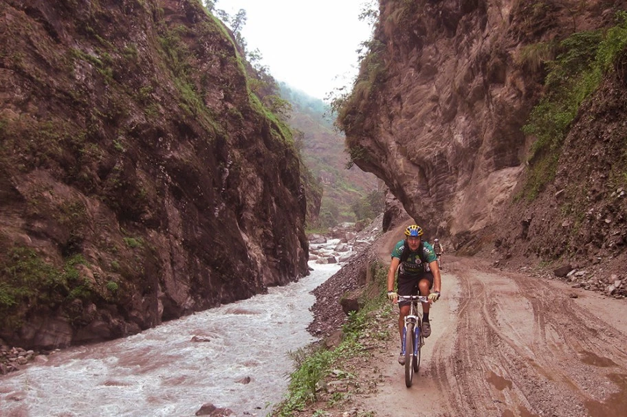
The beauty of the Annapurna, is that it is not just hikers that head along this route but cyclists as well. This is an epic bikepack
The beauty of the Annapurna, is that it is not just hikers that head along this route but cyclists as well. This is an epic bikepack
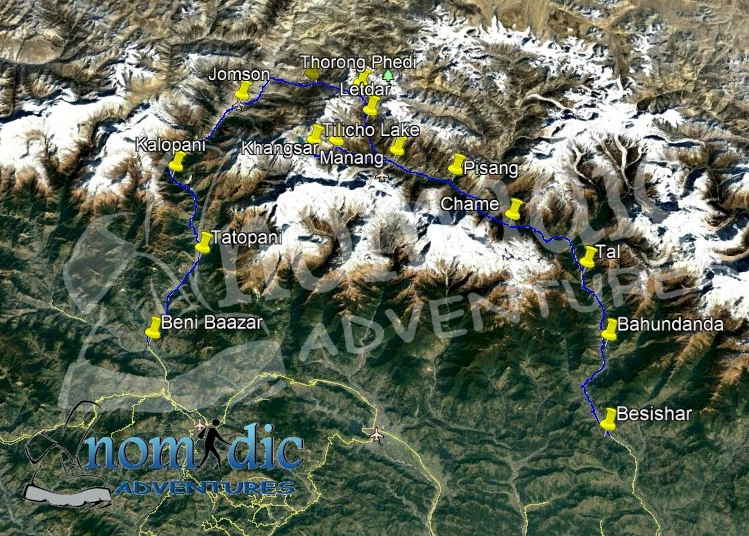
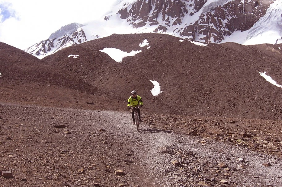
The Tilicho Lake Mountain Biking Tour is one of Nepal’s most thrilling and challenging adventures, combining high-altitude cycling with the rugged beauty of the Annapurna range. Tilicho Lake, at an elevation of 4,949 meters, is one of the highest lakes in the world, offering a truly unique destination for mountain biking enthusiasts. This demanding bike tour follows the Annapurna Circuit, crossing various eco-zones and providing spectacular views of peaks like Tilicho Peak (7,134m) and Dhaulagiri, all while navigating technical terrains and thrilling descents.
The Tilicho Lake Bike Tour begins in the Marsyangdi Valley and follows a well-established route that takes riders through the stunning Kali Gandaki valley, crossing the Sujena La Pass at 5,460 meters. This challenging pass offers panoramic views of the Dhaulagiri range and the Upper Mustang Valley, making the journey both a physical and visual feast.
As the ascent increases, experience diverse landscapes, including steep mountain paths, alpine meadows, and high-altitude terrain, demanding strong technical biking skills, especially on the downhill section from Mesukantu-La Pass (5,300 meters).
The route to Tilicho Lake is more demanding than most, requiring at least two nights of camping, as there are no tea houses or lodges beyond Tilicho Base Camp. Riders will camp along the way, experiencing the true wilderness of Nepal’s Himalayas. The area around Tilicho Lake is rich in biodiversity, with a variety of plant species and wildlife, offering a perfect blend of adventure and nature.
While this route is not recommended for beginners due to its technicality and altitude, it is a must-do for skilled cyclists seeking a once-in-a-lifetime challenge.
The Tilicho Lake Mountain Bike Tour is a highly rewarding journey for those ready to test their endurance and bike-handling abilities in one of the world’s most beautiful and rugged terrains. From the technical climbs to the exhilarating descents, this adventure is tailored for those with a passion for mountain biking and the thrill of high-altitude challenges.For those seeking a multi-faceted Himalayan adventure, the Tilicho Lake Bike Tour through the Annapurna Circuit offers the perfect blend of spectacular landscapes. Whether you're traversing technical trails, camping under the stars, or soaking in the panoramic views, this tour promises a truly unforgettable adventure in the heart of the Himalayas..
If you are looking for answers to specific questions, read here or go here to see
some of our blog posts
Note: All distances are approximate and vary according to road and route conditions
Day-1: Arrive Kathmandu
Arrival and transfer to Hotel.
Day-2: Guided Sightseeing
Guided sightseeing around Kathmandu valley.
Day-3: Drive: Kathmandu / Besishar (760m) / Khundi (790m)
After breakfast, we drive via Besisahar to Khundi by our private vehicle. This can take up to seven hours. Your adventure vacation truly starts the moment you reach Khundi. We stay overnight in local Lodge.
Day-4: Khudi / Bhaunadanda (1310m) Distance: 19km, 4 hrs
The changes in the valley's ecosystem and its physical characteristics quickly become evident. The incredible Himalchuli summit rises to the east. After crossing the river, we head to the east bank and pass through the village of Bhulbhule and then head north to Ngadi at 930m asl. We then continue to the ridge top settlement of Bahundanda at 1311m. The name of this village literally means "Brahmin Hill".
Day-5: Bhaunadanda / Tal (1700m)
Cycle: 12km, Rideable 45%, 6 hrs
We descend to the valley floor and then, after crossing the river, we climb steeply up a ridge to follow a trail which has been carved out of the rock wall of the valley. We pass through Khani Gaoon and Ghermu until we reach Sangye. From here, we continue along the West Bank of the Marsyangdi River through the village of Jagat to Chamje where we will cross the river to its eastern bank to enter the Manang District at the village of Tal. As we head up river, we will begin to notice the changes in the people as well as the land, architecture and culture. You will notice that there is a concentration of people of Tibetan origin, their houses are built of rock, the vegetation is less tropical and the culture is predominantly Tibetan.
 Day-6: Tal / Chame (2670m)
Total Cycle: 21.8km, 985hm, Rideable 60%, Time: 7 hrs. The trail from Tal crosses the Marsyangdi Khola to its West Bank after the village of Karte and continues towards the village of Dharapani.From Dharapani we continue up the river valley past the Gurung village of Thonje to the village of Bagarchap. Bagarchap means "Butcher's place". Continuing along the left bank, we climb up the heavily wooded Manang Valley past small settlements with excellent views of Manaslu and the peaks above Larkya La. We stay at the village of Chame, administrative headquarters of the region and the last major market before Jomsom.Chame also has a police check post and bank.
Day-7: Chame / Pisang (3300m)
Cycle: 16.4km, Rideable 48%, 6 hrs
From Chame the trail condition changes, somewhat. The continuing trail is not as well maintained as the one up to Chame. We pass through pine forests, over fairly level ground, through the village of Taleku to Bhratang. Like all villages since Dharapani these predominantly Buddhist villages have an entrance chorten and an exit chorten. Annapurna II can be seen to the south and you are now behind the main Himalaya peaks in their rain shadow area. After crossing a series of wooden cantilever bridges we enter a spruce and fir forest that eventually gives way to a pine forest. After days in the gorge the forests provide a welcome change. Crossing the river to its left bank we reach at the village of Pisang. You may want to visit the village before dinner.
Day-8: Pisang / Manang (3540m)
Total Distance: 17.2km,Rideable 95%, 5 hrs.
We are now in the dry arid region of Manang called Nyesyang. Since this area falls in the rain shadow area of the Himalaya it seldom rains in the summer months, though it snows in the winter and the snow remains on the ground for a long time. The population is mostly farmers and traders. People in this area keep comparatively less domestic animals and the consumption of meat is very limited There are two routes leading out of Pisang towards the Manang valley. The one we will follow keeps to valley floor, on the left bank. Spectacular views of Annapurna III and IV along with Gangapuran and Tilicho peaks abound. This is possibly the best day for viewing mountains. You will pass through the village of Hongde where there is a STOL airfield servicing the Manang district.
 Day-9: Manang / Khangsar (3,750m)
Total Cycle: estimated 12-15km , Rideable 50%, 5 hrs.
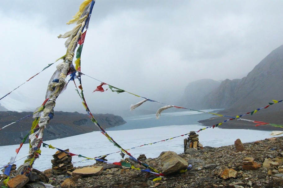
Today we will take a side trip towards Tilicho Lake. The route is rarely used by bikers. The terrain is difficult but is exquisitely beautiful.
Day-10: Khangsar / Tilicho Lake Base Camp (4,200m)
Total Distance: estimated 8km , Rideable 55%, 4 hrs
Today we head along a single-track past Khangsar which will take us to the Tilicho Base Camp, surrounded by high snowy peaks. This section of the trail is narrow and requires careful concentration.
Day-11: Early morning ride to the Tilicho Lake and back to Khangsar (3,750m)
Total Distance: estimated 12-15km Rideable 40%,
The adventure never stops as today, we cross the 5000m altitude barrier. We ride up the rocky terrain and seemingly endless snow ramps toward the magical Tilicho Lake and then cycle back to Khangsar for overnight stay.
Day-12: Khangsar / Manang (3540m)
Total Distance: estimated 12-15km , Rideable 50%, 4 hrs
We follow the same route back to Manang
Day-13: Continue to Letdar (4200m)
Total Distance: estimated 12-15km Rideable 75%, 4 hrs
After Manang, the trail climbs steeply to the village of Tenki, which is the last permanent settlement, this side of the Thorung La. We climb a little further and then contour slowly past various pastures to Yak Kharka (literally meaning Yak Pastures) to stay at Letdar.
Day-14: Letdar / Thorung Phedi (4450m
Total : 19km,, Rideable 75%, 9-10hrs
Today we continue through the, which eventually give way to a high arid desert at Phedi, at the base of Thorung La. Lodge.
Day-15: Cross Thorung La (5416m), Continue to Muktinath (3800m)
Total : 22.4km, 966hm, Rideable 60%,
After leaving the river valley we set out early in the morning provided the weather is good and it is not snowing. From Phedi we ascend to an outcrop and the turn left towards Thorung La. A chain of rocks marks the pass. Beyond the pass you enter the river valley of the Kali Gandaki River. The descent from the pass to Muktinath is steep but not difficult. Muktinath is a sacred pilgrimage site to both Hindus and Buddhists who flock there annually for their respective festivals. A rest day here allows you the opportunity to explore the area and the ancient shrines. Of particular interest is the temple of the Hindu God Vishnu and the one hundred and eight waterspouts where devotees bathe. From Muktinath there are beautiful views of Mt. Dhaulagiri (8167 m).

Day-16: Muktinath to Jomsom (2710m)
Total : 25.6km, Rideable 95%
We cycle along a level but rocky trail through juniper thickets to Jomson. In the late afternoon it gets very windy and so face masks are required. Take care to guard your eyes and cover as much of your skin surface as possible.
Day-17: Jomsom / Kalopani (2530m)
Total Cycle: 26.2km, Rideable 90%, 7 hrs
We cycle by the side of the Kali Gandaki river passing through the villages of Thakali, Marpha, Tukuche and Larjung. Then it is easy riding from here on in as they have built a jeep track to Kalopani. This is a beautiful village right below the base of Dhaulagiri mountain. The place is ideal to see panoramic views of the mountains including Nilgiri peaks and Annapurna I.
Day-18: Kalopani / Tatopani (1190m)
Total Cycle: 24.4km, Rideable 75%, 6 hrs
We enjoy the downhill before negotiating a technical section. We ride past a suspension bridge and continue through the dense pine forests. When we reach Ghasa there are some really good lodges. The trail ahead is steep until the Ruptse stream. Though it is early, we stop for a relaxing lunch and enjoy the scenery knowing that the trail ahead is much easier. We ride past the Dana village and after seemingly endless rice fields finally reach Tatopani. It is a small town at the north bank of Kali Gandaki River, famous for the hot springs and of course cold beer if you like. Lodge.
Day-19: Bike until Beni Bazaar (830m). Drive to Pokhara (79km)
Total Cycle: 24km, 90%
The trail follows the Kali Gandaki River through the world's deepest gorge to reach Beni. This is a fun day, with an excellent trail and a section of new road. Beni is the headquarters of Parbat District and has many shops and hotels. From here we take a bus for the 78km to Pokhara. Overnight Lodge.
Day-20: Fly to Kathmandu (1310m)
After breakfast, we will return to Kathmandu (just half an hour). Our bikes will be sent back by jeep. Overnight Hotel.
Day-21: Kathmandu.
Free at leisure for shopping, etc. On the remaining time you can relax, shop or go sightseeing. Evening we invite you on a farewell dinner. Stay at Hotel.
Day-22: Free at leisure to explore, and enjoy
Day-23: Final Departure.
End of services
Between Cho La, Kongma La, and Renjo La, which pass is more difficult?
Well for a start the three passes trek is incredible and if you can do all three then do. Each pass has its own difficulties. Renjo is a long slow pass and more of a ridge than a pass itself. It is spectacular and more remote than the other two as it goes via the … Continue reading
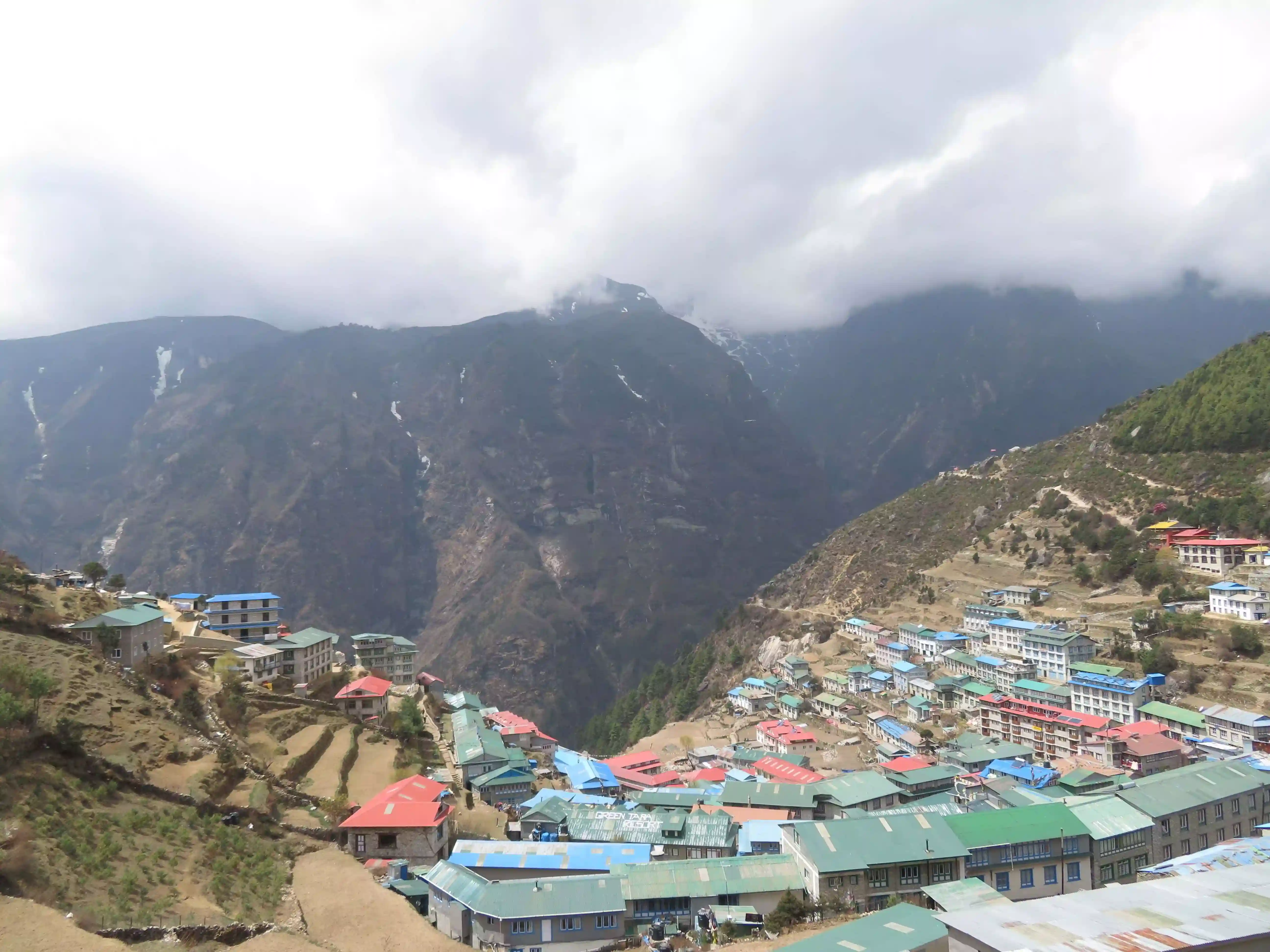
The Baazar Near the Top of the World
There is very little that Namche lacks. It even boasts the world’s highest Irish pub offering everything from Jameson whiskey to Guinness. It sports a sign as you enter that strikes to the heart and soul of what Namche and her people are all about.… Continue reading
We are often asked which is better, Mera Peak or Island Peak and although there are similarities and differences, it is hard to judge one over the other. So let us look at what makes them similar..Continue reading
Everest Base Camp or Advanced Base Camp
We are often asked which is the better of the two treks, Everest
advanced base camp from Tibet (north side) or Everest base camp from
Nepal (south side). It really is not an easy question to answer as it
all depends on what you are hoping to get out of the trek. Advanced
Everest Base Camp - 6340m Tibet … Continue reading
Altitude is much like elevation only it refers to the distance measured
above a specific planetary point, and in most places, this is the
distance above sea level. So if we live at the sea, how do we train for
high altitude? Getting technical about O2 and altitude At sea-level, the
concentration of oxygen in … Continue reading
KEEPING YOUR CELL PHONE ALIVE ON at altitude
Well the answer is quite simple – snuggle up with all of your batteries
at night or as soon as the temperatures drop. Packing a spars pair of
warm thermal and mohair socks will go a long way to creating a nice warm
package for all of your batteries. Continue reading
What is happening with Everest Advanced Base Camp in 2019?
Well, let’s cover some history first… the history of this area has been subjected to several issues over time. For a start, Tibet is to be closed to tourists between 30 January 2018 and April 1 April 2019 as usual.
Continue readingHow hard is it to hike to Everest Base Camp compared to Kilimanjaro? Most people think Everest Base Camp is higher than Kilimanjaro but surprise surprise, it is not. Base camp of Everest (or rather Kala Pathar – the little hill you climb up above base camp) is actually 5545m, whereas Kilimanjaro summit is 5895m.Continue reading
these boots are made for walking
Kilimanjaro, the Inca Trail, Everest Base camp or a simple short hike on local trails. We all dream of these amazing places and for some of us, turning those dreams into a reality is like a brand new lease on life.
Continue reading